|
|||||||||||
|
|
||
|
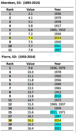
The ongoing winter of 2013-2014 will go down as one of the coldest December through February periods on record across central and northeast South Dakota as well as west central Minnesota. Countless clipper systems moving across the region brought periods of snowfall, Arctic air, strong winds along with bitter cold wind chills and blowing snow. Despite the lack of snowfall, the strong winds and Arctic cold resulted in several blizzard and high wind warnings along with many wind chill advisories and warnings. The meteorological winter is the period from December 1st through February 28th even though winter conditions in our region can begin much earlier and last much longer. |
||
|
the east. In the east, the snowfall amounts ranged from 17.4 inches at Watertown to 24.4 inches at Aberdeen. In central South Dakota, the snowfall amounts ranged from 24.9 inches at Pierre to 31.4 inches at Mobridge. Despite having more snow than locations in the east, Pierre and Mobridge were able to melt most of it off while the east remained snow covered. Snow cover allows for better cooling at night and less warming during the daytime. Therefore, this winter could have been several degrees colder with a deeper and more widespread snowpack across the region. It is a good thing we did not have to find out how cold it may have been. With March (Continued on page 8) |
||
|
|
||